
Earth Science Manufacturer, Suppliers and Exporter in India
School Instrument India is leading Earth Science Manufacturer,and supplier and Exporter in India, Algeria (Algiers), Angola (Luanda), Argentina (Buenos Aires), Armenia (Yerevan), Australia(Canberra), Austria (Vienna), Bahrain (Manama), Bangladesh (Dhaka), Bhutan (Thimphu), Bolivia (Sucre), Botswana (Gaborone), Brazil (Brasília), Brunei (Bandar Seri Begawan), Montenegro (Podgorica), Morocco (Rabat), Mozambique (Maputo), Myanmar (Naypyidaw), Namibia (Windhoek), Nepal (Kathmandu), New Zealand (Wellington), Nigeria (Abuja), Oman (Muscat), Palestine (Ramallah), Panama (Panama City), Papua New Guinea (Port Moresby), Paraguay (Asunción), Peru (Lima), Philippines (Manila)¸ Portugal (Lisbon), Qatar (Doha), Rwanda (Kigali), Saudi Arabia (Riyadh), Senegal (Dakar), Serbia (Belgrade), Sierra Leone (Freetown), Slovakia (Bratislava), South Africa (Cape Town) (Pretoria) (Bloemfontein), South Sudan (Juba), Spain (Madrid), Sri Lanka (Sri Jayawardenepura Kotte) (Colombo), Sudan (Khartoum), Syria (Damascus), Tanzania (Dodoma), Thailand (Bangkok), Togo (Lomé), Tonga (Nuku'alofa), Trinidad and Tobago (Port of Spain), Tunisia (Tunis), Turkey (Ankara), Turkmenistan (Ashgabat), Uganda (Kampala), United Arab Emirates (Abu Dhabi), United Kingdom (London), United States (Washington, D.C.) Earth science is the study of the planet Earth. Earth science is especially interested in what the planet is composed of, its weather, and how the planet developed and continues to change over time. Many different sciences, such as geology and meteorology--the study of weather--are part of earth science.Light & Optics Manufacturer, Earth Science Suppliers, Earth Science Exporters, Earth Science online india, Light & Optics, Earth Science, Spectrometers and Spectrum Tubes, Earth Science Manufacturers in India.

Large Magnetic Compass
Product Code : SCL-ES-11323
The Large Magnetic Compass is a ruggedized 90mm diameter instrument engineered for the quantitative analysis of geomagnetic field orientation and directional navigation.
View Details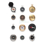
Magnetic Compasses
Product Code : SCL-ES-11324
This range of Magnetic Lab Compasses is engineered for high-precision plotting, field mapping, and the empirical analysis of electromagnetic flux.
View Details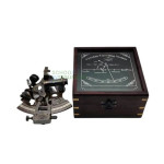
Sextant, Brass
Product Code : SCL-ES-11325
The Nautical Brass Sextant is a precision instrument engineered for celestial altitude measurements and the empirical determination of geographic coordinates.
View Details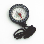
Compass, Liquid-Filled Magnetic
Product Code : SCL-ES-11326
The Liquid-Filled Magnetic Compass is a ruggedized navigational instrument engineered for stabilized azimuth determination and field-based topographic mapping.
View Details
Tectonics Model Set - Learning About Faults, Folds and Plate Movements
Product Code : SCL-ES-11327
The Tectonics Model Ensemble is a high-fidelity analytical system engineered for the 3D demonstration of lithospheric boundary interactions and crustal deformation.
View Details
Mapping Compass
Product Code : SCL-ES-11328
The Mapping and Orienteering Compass is a ruggedized navigational instrument engineered for precise bearing determination and topographic map overlays.
View Details
Mini Weather Station
Product Code : SCL-ES-11329
The Integrated Meteorological Observation Unit is engineered for the empirical measurement of micro-climate variables, including thermal gradients, anemometry, and precipitation.
View Details
Solar Eclipse Glasses
Product Code : SCL-ES-11330
Solar Eclipse Filtration Eyewear is engineered for the direct, high-optical-density observation of solar phenomena.
View Details
Clinometer
Product Code : SCL-ES-11331
This precision Clinometer is engineered for the empirical determination of vertical heights and inclination gradients through angular measurement.
View Details
Soil Sifter
Product Code : SCL-ES-11332
The Sieve Analysis Station is a ruggedized field instrument engineered for the gravimetric separation of soil particles and sediment classification.
View Details
Moon Globe 5.5"
Product Code : SCL-ES-11333
The Topographic Lunar Globe is a high-resolution 5.5" diameter instructional instrument engineered for the spatial analysis of lunar geomorphology and Apollo landing site trajectories.
View Details
Humidity and Temperature Probe
Product Code : SCL-ES-11334
The Digital Thermohygrometric Probe is a high-precision, small-form-factor instrument engineered for real-time monitoring of ambient thermal gradients and relative humidity.
View Details
Antiquity Globes
Product Code : SCL-ES-11969
The Antiquity Cartographic Globe is a high-resolution terrestrial reference instrument designed for the empirical study of historical cartography and geopolitical boundaries.
View Details
Dual Maps
Product Code : SCL-ES-11970
The Dual-Perspective Cartographic Series provides high-fidelity, synchronous analysis of political boundaries and physical geomorphology.
View Details
Geographical Globes, Superior
Product Code : SCL-ES-11971
The Geographical Reference Globe is a high-precision terrestrial instrument engineered for the empirical study of global topography, coordinate systems.
View Details
German Print Maps
Product Code : SCL-ES-11972
The Westermann Cartographic Series is a high-resolution, German-print pedagogical reference system engineered for the precise study of regional and global geomorphology.
View Details
Globe with Ocean
Product Code : SCL-ES-11973
The Illuminated 2-in-1 Terrestrial Globe is a dual-state cartographic instrument calibrated for the empirical study of physical oceanography and geopolitical boundaries.
View Details
Globes, Illuminated
Product Code : SCL-ES-11974
The Geographical Illuminated 2-in-1 Globe is a dual-state terrestrial reference instrument designed for the empirical study of physical geomorphology and geopolitical boundaries.
View Details
Philip School Map
Product Code : SCL-ES-11975
The High-Resolution Cartographic Series is a large-format instructional reference system engineered for the empirical study.
View Details
Physical Shading Globe
Product Code : SCL-ES-11976
The Physical Shading Terrestrial Globe is a high-resolution cartographic reference instrument engineered for the simultaneous analysis of geopolitical boundaries and topographical relief.
View Details
Plastic Wall Maps
Product Code : SCL-ES-11977
The Environmental and Geopolitical Wall Map Series provides high-fidelity spatial data for the analysis of global ecosystems and administrative infrastructures.
View Details
3D Relief Models- I
Product Code : SCL-ES-11978
The 3D Geomorphological Relief Series is a collection of high-resolution, rigid PVC topographic models engineered for the empirical analysis of lithological cycles and tectonic dynamics.
View Details
3D Relief Models- II
Product Code : SCL-ES-11979
The 3D Geomorphological Relief Series II is a collection of high-resolution, rigid PVC diagnostic models engineered for the empirical.
View Details
Alpine Glacier Model
Product Code : SCL-ES-11980
The Alpine Glacier Comparative Relief Model is a dual-part diagnostic instrument engineered for the empirical study of cryospheric dynamics and post-glacial geomorphology.
View Details
Contour Map
Product Code : SCL-ES-11981
The Contour Gradient Relief Model is a precision-engineered 3D analytical tool designed for the empirical study of topographical mapping and geomorphology.
View Details
Fault Folding Demo
Product Code : SCL-ES-11982
The Fault and Folding Tectonic Demonstrator is a high-precision kinematic model engineered for the empirical analysis of lithospheric deformation and orogenic processes.
View Details.jpg)
Fold Model (Demo Model)
Product Code : SCL-ES-11983
The Crustal Fold Demonstration Model is a precision-calibrated mechanical instrument designed for the empirical study of lithospheric deformation and orogenic processes.
View Details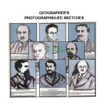
Geographer Sketches, 3D
Product Code : SCL-ES-11984
The 3D Geographer Bio-Sketch Series is a specialized pedagogical reference system engineered for the empirical study of cartographic history and geographical theory.
View Details
Land Form Evolution
Product Code : SCL-ES-11985
The Land Form Evolution Model is a precision-engineered diagnostic instrument designed for the empirical study of tectonic folding and subsequent denudation processes.
View Details
Map Reading Model
Product Code : SCL-ES-11988
The Map Reading and Topographic Interpretation Model is a specialized diagnostic instrument engineered for the empirical study of planimetric data translation.
View Details
Map of The World, 3D
Product Code : SCL-ES-11987
The World Map 3D Raised Relief is a high-precision cartographic instrument engineered for the empirical study of global geomorphology and ocean floor bathymetry.
View Details
Model Island Formation
Product Code : SCL-ES-11989
The Map Reading and Topographic Interpretation Model is a specialized diagnostic instrument engineered for the empirical study of planimetric data translation.
View Details
Model of Volcano
Product Code : SCL-ES-11990
The Sectioned Volcano Internal Structure Model is a high-fidelity diagnostic instrument engineered for the empirical analysis of magmatic conduits and eruptive geomorphology.
View Details
Planet Model
Product Code : SCL-ES-11991
The Solar System Planar Scale Model is a high-fidelity 3D instructional plaque engineered for the empirical study of celestial mechanics and planetary proportions.
View Details
Plate Tectonics
Product Code : SCL-ES-11992
The Plate Tectonics Kinematic Relief Model is a multi-dimensional diagnostic instrument engineered for the empirical analysis of convergent, divergent, and transform boundary interactions.
View Details
Weather Model
Product Code : SCL-ES-11994
The Cyclonic Storm and Frontal Systems Model is a diagnostic 3D atmospheric simulator engineered for the empirical analysis of air mass boundaries.
View Details
Terrain Model
Product Code : SCL-ES-11995
The Comparative Terrain Geomorphology Model Set is a dual-component diagnostic instrument engineered for the empirical study of orogenic evolution and denudation.
View Details